 A visual metaphor for TLE-driven satellite tracking
01An Orbit Description, Not A GPS Fix
A two-line element set, or TLE, describes an Earth-orbiting object's orbit at an epoch: the reference time for that set of elements. A compatible propagation model uses the elements and a requested time to calculate position and velocity. The text is neither a stream of GPS fixes nor a measured trail of points.
JOT (Jewawud Orbital Tracker) uses orbital data to draw a moving satellite map. Seeing a dot move every frame does not mean new tracking observations arrive every frame. The clock can advance while the underlying element set remains unchanged.
02Which Fields Should You Read First?
A TLE has two 69-character lines, sometimes preceded by a name. Line 1 identifies the object and epoch. Line 2 describes orbital geometry and mean motion.
Both catalog numbers must match. Inclination is not current latitude. Eccentricity has an implied decimal point: 0005000 means 0.0005000. A final checksum helps detect some transcription errors, but does not establish orbit accuracy or data freshness. The CelesTrak format reference specifies the columns.
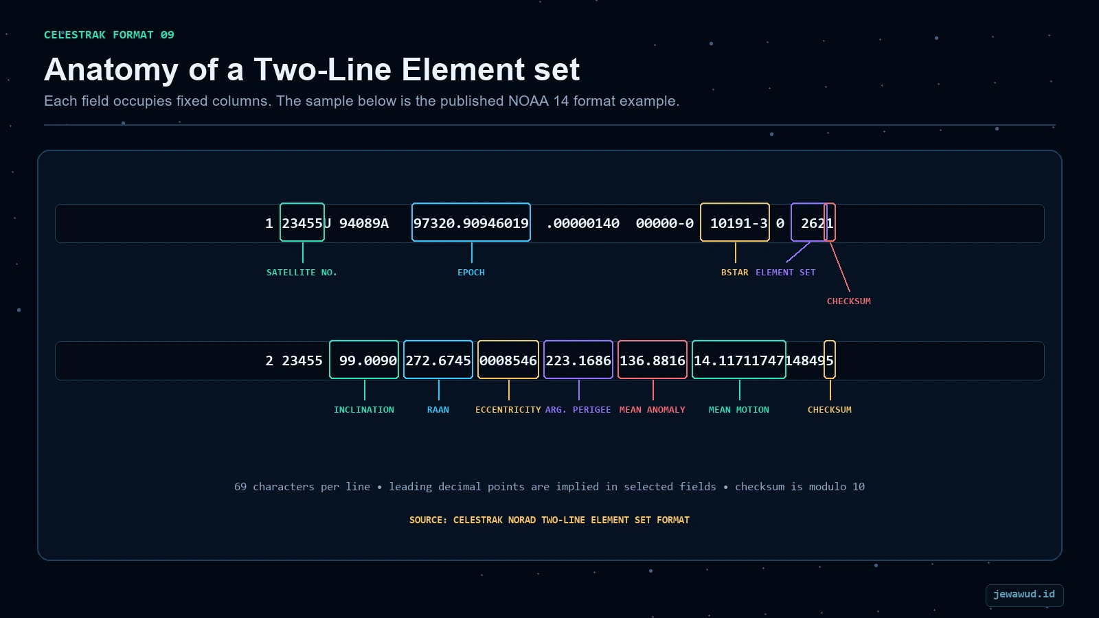 Key fields in CelesTrak's NOAA 14 example; each TLE line contains 69 fixed-column characters
03Read An Epoch Without Guessing
Consider the illustrative epoch field 26258.50000000. This is a teaching fragment, not a current ISS element set. The year is 2026, the day number is 258, and the fraction is half a day. Counting January 1 as day 1 gives September 15, 2026 at 12:00 UTC.
At September 16, 2026 at 00:00 UTC, those elements would be twelve hours old. Downloading them at that moment would not reset their epoch. Keep three times separate: when the orbit is referenced, when the file was retrieved, and when a position was calculated.
The legacy two-digit-year convention maps 57-99 to 1957-1999 and 00-56 to 2000-2056. It is a format rule, not a reason to guess the century from the satellite name. Kelso's format FAQ explains epoch interpretation.
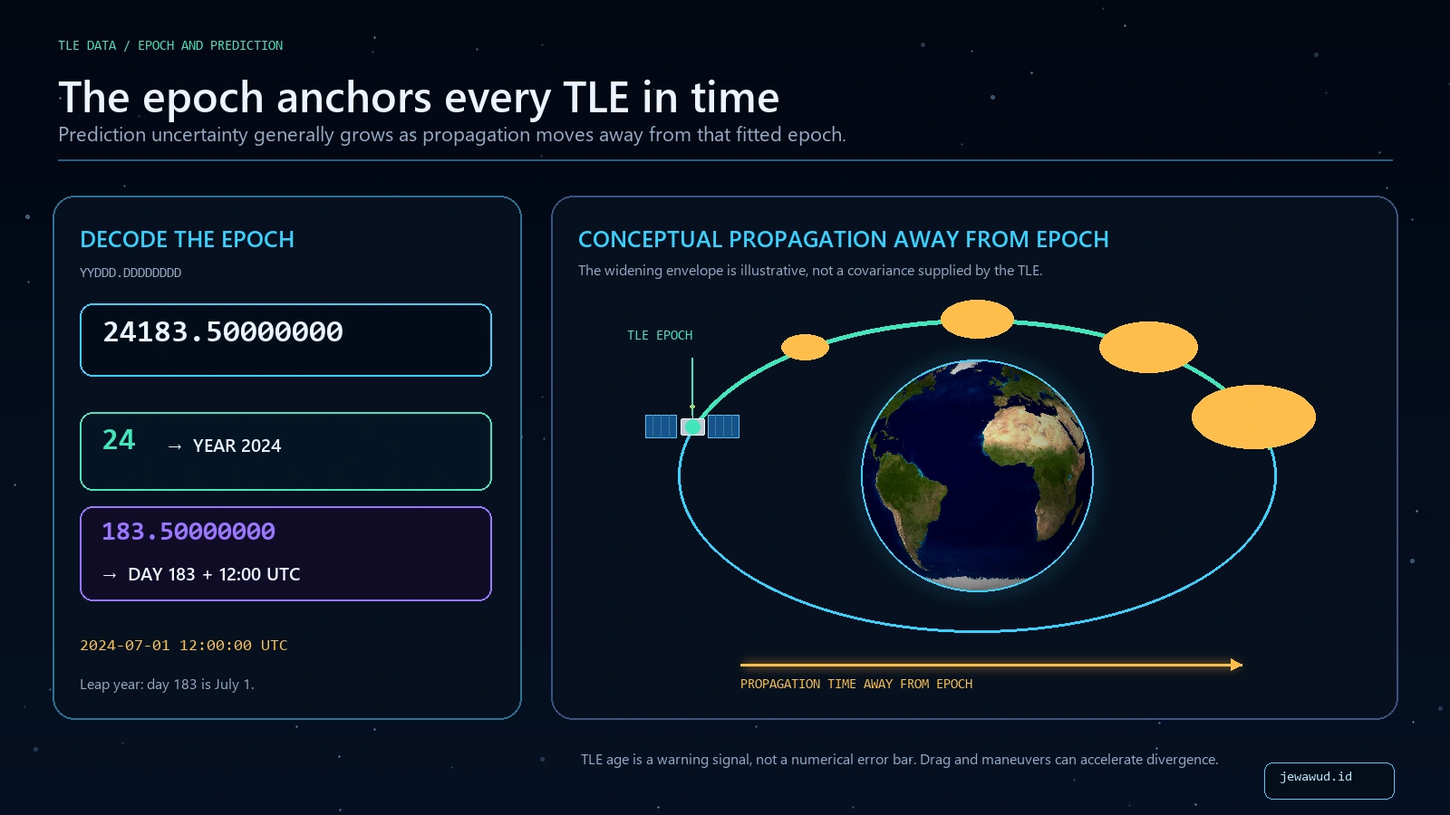 The epoch anchors the element set in time; prediction uncertainty generally grows farther from it
04Turn Mean Motion Into An Approximate Period
Suppose a teaching example gives mean motion 15.50000000 revolutions per day. Divide the 1,440 minutes in a day by that value:
1,440 / 15.5 = 92.90 minutes, or about 1 hour 32 minutes 54 seconds per revolution. This calculation is reproducible without running a tracker. It does not predict a pass over your city: Earth rotates beneath the orbit, and the orbital plane and observer position still matter.
This is a mean-motion-derived period, not a claim that every successive observed revolution has exactly that duration. It also does not tell you how fast the object moves at every point of an eccentric orbit. The input unit is documented in CelesTrak's line-2 definition.
05How The Elements Become A Map Position
TLE mean elements are fitted for the SGP4 family of models. Treating them as interchangeable with arbitrary instantaneous Keplerian elements can produce a different trajectory. SGP4 returns position and velocity in the True Equator, Mean Equinox (TEME) reference frame, not directly as latitude and longitude. CelesTrak's propagation FAQ explains the model and frame distinction.
The tracker then accounts for Earth's rotation, expresses the position in an Earth-fixed frame, and converts it to geographic coordinates. Sampling several times produces the orbit preview or ground track. A smooth line is evidence of rendering, not independent evidence that the orbit is accurate.
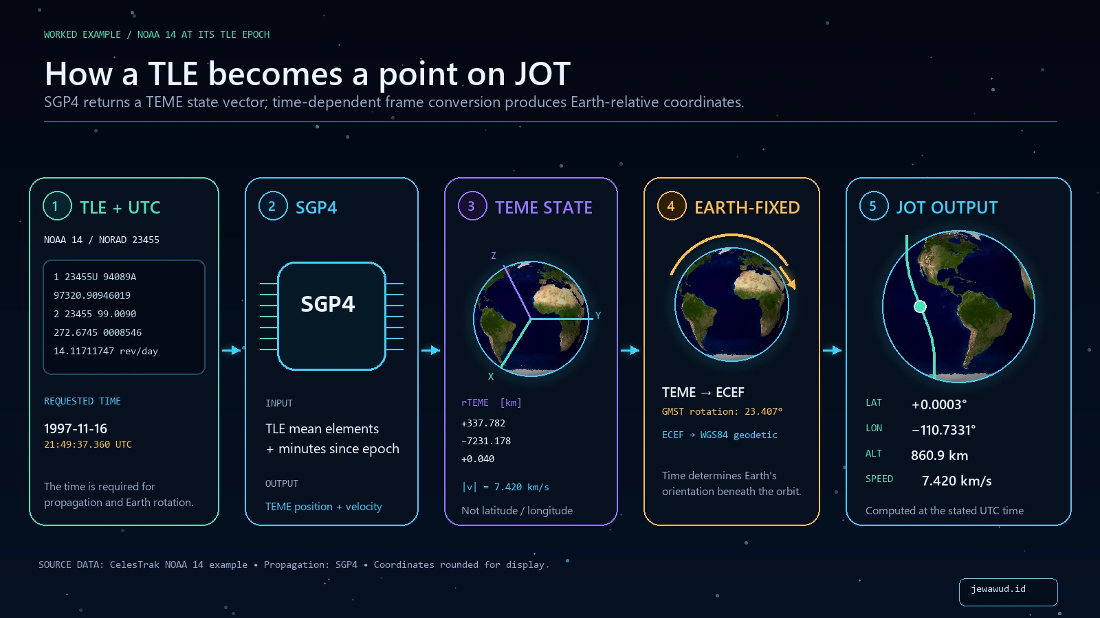 A tracker propagates the TLE at a requested time, changes reference frames, then renders readable telemetry
06Why Two Trackers Can Disagree
Compare the catalog ID first, then the epoch and requested UTC time. Different element sets can produce different predictions, especially around maneuvers. A model fitted before a station reboost does not automatically include the later burn. CelesTrak also cautions that accuracy depends on the object and its orbit; it is not one universal number. See the accuracy discussion.
As a scale illustration, an object moving at an assumed 7.7 kilometres per second travels about 462 kilometres along its orbit in one minute. That is not a promised map-position error, but it shows why comparing screenshots taken at different times can mislead.
A TLE age is not an error bar. Do not convert “one day old” into a fixed kilometre uncertainty without evidence. Public orbit displays are useful for learning and observational planning, not a substitute for operational collision screening.
07A Practical Check In Jewawud
Open the ISS catalog record and note the epoch attached to its orbital snapshot. Keep that tab open, then open the same NORAD ID in JOT. Comparing the ID avoids confusing a station with another similarly named object.
Record the displayed time and position twice, about a minute apart. Movement with an unchanged epoch illustrates propagation from one dataset. If the catalog reports stale data or disables a prediction, do not replace the warning with an assumed current location. A failed live-data request also cannot demonstrate that the spacecraft has stopped moving.
This exercise checks how a display uses its data; it does not independently validate that data against tracking observations. For the frame-conversion details, continue with What Is SGP4?.
08The Same Orbit Data Can Arrive Without Two Text Lines
CelesTrak also distributes general perturbations data in formats including OMM XML/KVN and JSON/CSV using OMM field definitions. A structured response is not automatically a more accurate orbit: the model, element values, epoch and provenance still matter. Conversely, an app does not have to receive literal TLE text to use SGP4-compatible data. CelesTrak's GP data-format guide describes the alternatives.
Follow One Object
Compare a dated catalog snapshot with its calculated position in the orbital map.
Open ISS In JOT